Introduction To Operation Storm-Front

Operation Storm-front is a private research project with a goal to collect barometric pressure, temperature, dew point, and humidity data during a scheduled time of severe weather. This research project is being done in hopes to fully understand the concept behind a severe thunderstorm to help with prediction improvements.

The truth about tornadoes and advanced warnings, according to NOAA, is current warnings have only a 13 minute average lead time and a 70% false alarm rate. The tornado is hard to forecast and is still not understood and is still unpredictable.

North Blue Springs wall cloud
North Blue Springs wall cloud on 7 highway looking north.

For this research, I will be focusing on the thunderstorm and not the tornado for one reason, the tornado is the end result of a severe thunderstorm. The tornado is not the source, the thunderstorm is. If we can understand the thunderstorm, and examine the data of the severe thunderstorm, there is a good possibility we will find the missing link to tornado-genesis. If we find the missing link we will solve our problems with severe weather predictions and know what storms will be associated with tornado-genesis. It seems like people can get so focused on the result, they look past the fact that they need to switch to the source! Just like a cancer, the focus needs to be the source of the cancer not just the cancer itself! That source of the tornado can only be one thing, the severe thunderstorm.

Grain Valley storm front
Grain Valley storm front.

Operation Storm-Front research project will be conducted as time is available. Data collection from a proprietary designed device and examinations of radar displays and visual examinations of storms will be vital to this extensive research project. As data that is collected will be compared to baseline data from days that have no forecast of severe weather. The ending results and all data will be posted on this site for any and all to use for other research projects. Blog entries will be posted as data is collected and discoveries are found.
June 23, 2019 Non-Severe Thunderstorm Event

06:37am Observed temperature 65 degrees. Feels like 67 degrees. Humidity 99%/. Pressure 1010mb and falling. Winds at 1mph ESE gusting to 6. Dew point 64. Skies partly cloudy. Rain measurement 1.34″.
0703am lightning detected at 12 miles.
0724am Rain started. Steady moderate. Observed temperature 65 degrees. Humidity 99%. Pressure 1012mb and falling. Winds 2mph W gusting to 5. 7 lightning strikes recorded.
0730am Heavy rain.
0736am Moderate rain.
0745 Light steady rain.
0749am Rain measurement .22 inches.
0804am moderate rain.
0815am Heavy rain..
0821am 21 lightning strikes recorded. Observed temperature 65 degrees. Humidity 99%. Dew point 64. Winds 1mph SW gusting to 5. Pressure 1013mb and steady.
0823am Rain steady.
0827am Rain measurement .70 inches.
0846am Observed localized flooding of curbs and street intersections. Water flowing over roadways in areas with approximately 1/2 inch of water.
1115am approximate time rain stopped.
1230pm Rain measurement 1.37 inches.
12:30pm Light mist.
0136pm 22 lightning strikes recorded.
0136pm Observed temperature 68 degrees. Humidity 99%. Pressure 1009mb and falling. Dew point 67. Winds 0mph SW gusting to 5.

NO FURTHER ENTRIES FOR THIS EVENT.

Events of The June 22, 2019 storm.

10:06pm Rain Started
10:07pm Heavy rains.
10:10pm Moderate Rain.
10:16pm Light sprinkle.
10:16pm Recorded winds 3mph WNW gusting to 7.
10:17pm Rains light steady.
10:18pm Lightning count 329.
10:23pm Observed temp 70 degrees. Humidity 95%. Dew point 68. Winds 2mph SSW gusting to 11.
10:24pm Rains light and steady,
10:27pm Severe Thunderstorm alert.
10:28pm Heavy rains and wind.
10:30pm Lightning count 404.
10:31pm Observed temp 69. Humidity 97%. Dew point 68. Winds 6mph SSW gusting to 11.
10:35pm Rains light and steady.
10:35 Winds 5mph WNW gusting to 11.
10:49pm winds calm rain steady and light.
10:49pm Observed temp 68. Humidity 99%. Dew point 67. Winds 3mph gusting to 11. 503 lightning strikes. Pressure 1016mb and steady.
10:57pm Rain recorded .81 inches.
11:24pm Rain recorded .87 inches.
11:24pm 538 lightning strikes recorded.
11:43pm Power loss for Sherwood Village and 7 highway recorded.

NO FURTHER ENTRIES

March 2 Snowmageddon Flop

What happened? What happened to the 4 to 6 inches of snow that was predicted and hyped up like it was the end of the world? What was the deal with the prediction? Where in the world did they get this prediction? I have yet to get an answer by our fearless professional weather folks. Hopefully someone from the NWS will answer this question. Where are you getting a model that is not found anywhere? Is this a wild guess based on the models or is this some sort of tactic to cause fear. I see it all the time. From this point forward I will make it my duty to compare my predictions with the predictions of the professionals whether I am right or wrong because I truly want to know why the predicted measurements were way off?

As I watched this storm and used several different resources to include the smart phone application called Windy you can see the PC version here. The next three images are what the Windy application predicted based on all 4 different models. You will noticed that ALL THREE of these models are fairly close in their predictions. So what gives?

February 27, 2019
March 1st 2019
March 2, 2019

So let’s take a look at another prediction taken from the Weather Prediction Center and the probability of snow up to 4 inches. Notice the 40% chance of precipitation up to 4 inches.

March 2-3 probibility

March 3rd prediction on measurements from the Weather Prediction Center.

If this model shows 2.8 inches why did the NWS predict 4-6 inches?

So these numbers from looking at the predictions and the charts and maps myself I was able to predict with fairly accurate numbers what we would get in precipitation and we ended up getting 2.75″ measuring from a white snowboard as CoCoRaHS recommends.

Hopefully a NWS professional can comment and enlighten me on the questions I have on this past weekends snow storm. Till next time!

The Importance of Weather Alerts

One type of alert to rely upon is never enough. That gives you one single point of failure. Seconds count in the event of a tornado. Tornado’s, are still to this day highly unpredictable, but have gotten better with advanced warnings. Sirens can fail, people can make a wrong judgement call behind the alert. Your phone alert can fail, your texts could never come through. You can lose power. Your cable or the television broadcast can go out.

Springfield, Mo Tornado February 2019.

A question often arises, how many services and alerts should I have? The answer is simple, as many as feasibly possible. Weather radio? Yes! Should not be an option. The basic weather radio such as the one I own that alerts on everything in your county works very well! I have had it for years and years and it has been a reliable little radio. It has battery backup as well. Just remember to change out those batteries every daylight savings time like your smoke detectors. Price Chopper carries these as well as Walmart. Some weather radios have the ability to add a flashing strobe for those that are hearing impaired as well. Other weather radios have the ability to filter out alerts you don’t want to be woken up to, such as flash flooding. I am actually eyeballing the Midland WR400 Deluxe weather radio. This radio is a combination weather/alarm clock, also has a USB charging port for your phone. This will free up space having both an alarm clock and my weather radio taking up space on my end table next to my bed.

Motorola WR-100
Midland WR400 Deluxe. Filters alerts plus it is an alarm clock.

Then there is the cell phone alerts. Here in Blue Springs we have a service put out by CJCEMA called Nixle where you receive texts to your phone. If you do not have Nixle you can sign up here.

There are plenty of weather apps for phones out there that can be used as well. One of the popular one’s I use are Wunderground and Windy which both are free. Then from a storm spotter perspective I also use a purchased app called Radar Scope (about 10 bucks) which is where the clips of radar I post on my Facebook page come from. It has a monthly subscription that gives radar scope a lot more options as well.

Warm, Cold, Rain, Snow in The Same Week!

The past few days have been quite the interesting events. We ended up with about 8.9 inches of snowfall on Friday/Saturday this past weekend. It was a difficult prediction even for a weather enthusiast like myself, but I will have to admit that this past storm was pretty impressive! Our atmosphere was saturated with moisture and caused big fat snow to fall and to accumulate on our trees and power lines. This became a problem for us as the weight of the snow would cause tree limbs and entire trees to fall and a lot of people lost power. Some won’t have power back till Thursday. Just in time for another round of snow to accumulate in our area.

Water Vapor from 1/11/2019

Our next round of systems will be another interesting set up.


1. Tuesday will be mid to upper 40’s. but may not be able to be high enough to melt a whole lot of the snow. That is the system coming up from southwest.

2. Wednesday afternoon we have another 60% chance of precipitation and the temperature will barely be above freezing at 33 degrees. This will occur well into Thursday

3. Friday evening into Saturday is the next system. Starting off with rain at 38 degrees. The temperature will tank once this system starts and by Saturday morning at about 1am the rain will transition to snow stopping about noon or a little after. Temperatures will continue to drop throughout the weekend and by 8am Sunday will be at -4 degrees if everything plays out. Temperatures will climb back up to the 30s by Monday afternoon.

I will keep an eye on this system and the models as the week progresses and will update with any changes that may occur. If you end up going to the Chief’s game make sure you bundle up in layers to keep warm! GO CHIEFS!

Are You Ready For A Warm Up?

Expect at a 5 to 10 degree warm up tomorrow. Clouds will be departing and offer up some sunshine. Temperatures will continue to increase and temperatures should reach back up into the the upper 40s lower 50s by the weekend. That chance of rain Thursday has gone away.

Wintry Mix Start Possible Tonight

The more I dig into the weather for tonight and tomorrow the more I think we will get some wintry mix. As the sun disappears behind the clouds. I have decided to remove the smaller gauge out of my rain collector in anticipation for this system moving in starting off with snow. It looks to be starting off with mix, moving to rain, then the colder air moving in behind the end of this system. Blue Springs may wake up to some light icing Monday morning then warm up and then additional icing on the predawn to several hours after sunrise on New Years.

The isobars indicate some higher winds since they are closer together. That alone may cause some freezing. We are expecting up to an inch of precipitation.

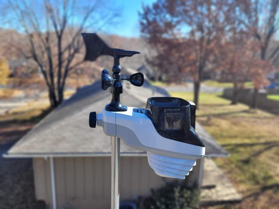
I look at the numbers on my Acu-Rite 5 in 1 and it shows 38 degrees F and steady. Humidity of 59% and falling. The Barometric pressure is 1011 millibars and falling. Winds are 5 mph west north west and a windchill of 35 degrees F.

Time to Get Back to Normal

Hope everyone enjoyed the nice 58 degree weather today. We are about to get back to our normal winter cold as the temperatures start to tank. Saturday morning may be in the single digits with the windchill, but we will be drying out. Sunday will be struggling to 40 degrees. The models show no precipitation up through the weekend.

Over the past 24 hours or so we have received 1.12 inches. It was breezy today. The most wind we received today was 22 mph.

Currently we are at 38 degrees and falling. Pressure 1002 and rising. Humidity is at 91% and rising. Winds are out of the west at 7 mph. Windchill at 31 degrees.