Blue Springs Weather: Possible Winter Storm

Good evening. It does not surprise me that Blue Springs weather shifts back and forth like menopause. This happens every season. Winter, spring, summer, fall. The last system was a fairly strong storm in places with only 0.25 inches or precipitation. Why is that? Why do we shift? Because the Earth does not rotate perfectly. It wobbles and, in turn, causes the weather to shift up and down.

Blue Springs Weather Forecast

For now, we are going to focus on the upcoming Friday weather. Mind you, this is still early and will definitely change and shift a little as we move forward. We will start at about 5 pm tomorrow (Thursday) night. It starts off as rain with the temperature at about 47°. According to the HRRR model for the current hour, the rain will shift to Sleet for a short time at 5 am, then shift to very heavy snow by 6 am. It seems that the snow amount, according to HRRR, is 4 inches. Don’t get excited. The WPC shows no real snow accumulation, and the WPC has yet to miss the mark.

So if anything changes, I will update it on social media. Please consider subscribing to my Weather Research site called Project Stormfront. From his site, you will see real science experiments and research papers based on real science. Eventually, I will have ways to support this page and my research on the weather. MP
Blue Springs Weather: Threat Upgrade

SPC Outlook

Blue Springs Weather is going to get pretty active tonight. I wanted to update you all on the upcoming storms we will encounter tonight. The Storm Prediction Center has upgraded us to Slight from Marginal. The more severe storms will be located more south, starting at the southern edge of Bates County, where they fall under an enhanced chance.

Blue Springs Severe Weather Forecast

Today we will be dealing with bouts of rain throughout the day and into the evening hours. Normally our temperatures will drop by the time evening hits us. This is not going to be the case today. Temperatures will be going up and the drop after midnight tonight. It is till a little bit early to the max temperature but it looks like we could be at 57° give or take by 10 pm.

  • Blue Springs Weather HRRR Model at 10pm
  • Blue Springs Weather Wind Gust Model

The threats we will be dealing with tonight will be damaging winds at a 15% chance, and large hail at 5%. Although our tornado chances are less than 2%, I am not going to rule out a possiblity of a spin up. We are still early in the game. This is all because we hit solar maximum with the current sun cycle. I am thinking things are going to start winding back down as be progress into spring and summer and the sun will go quiet again over the next year as we progress into another solar minimum. All a part of our transition into a Grand Solar Minimum.

That is about it for today on the forecast. I will update more on social media as things change. On another quick note I have been digging into solar intensity and temperature and found some interesting things. I will post that write up on my Weather Research site later. Take care everyone. MP.

Blue Springs Weather Daily Discussion

Good morning; here is the latest Blue Springs weather as of 05:26 am. We received 0.22 inches of precipitation over the past 24 hours. We did not get much from what was predicted yesterday. It was just enough to wet the ground, unfortunately. Not even a lightning strike. Looking forward to severe spring weather. You can get the rest of the long-range forecast here.

Current Blue Springs Weather Conditions

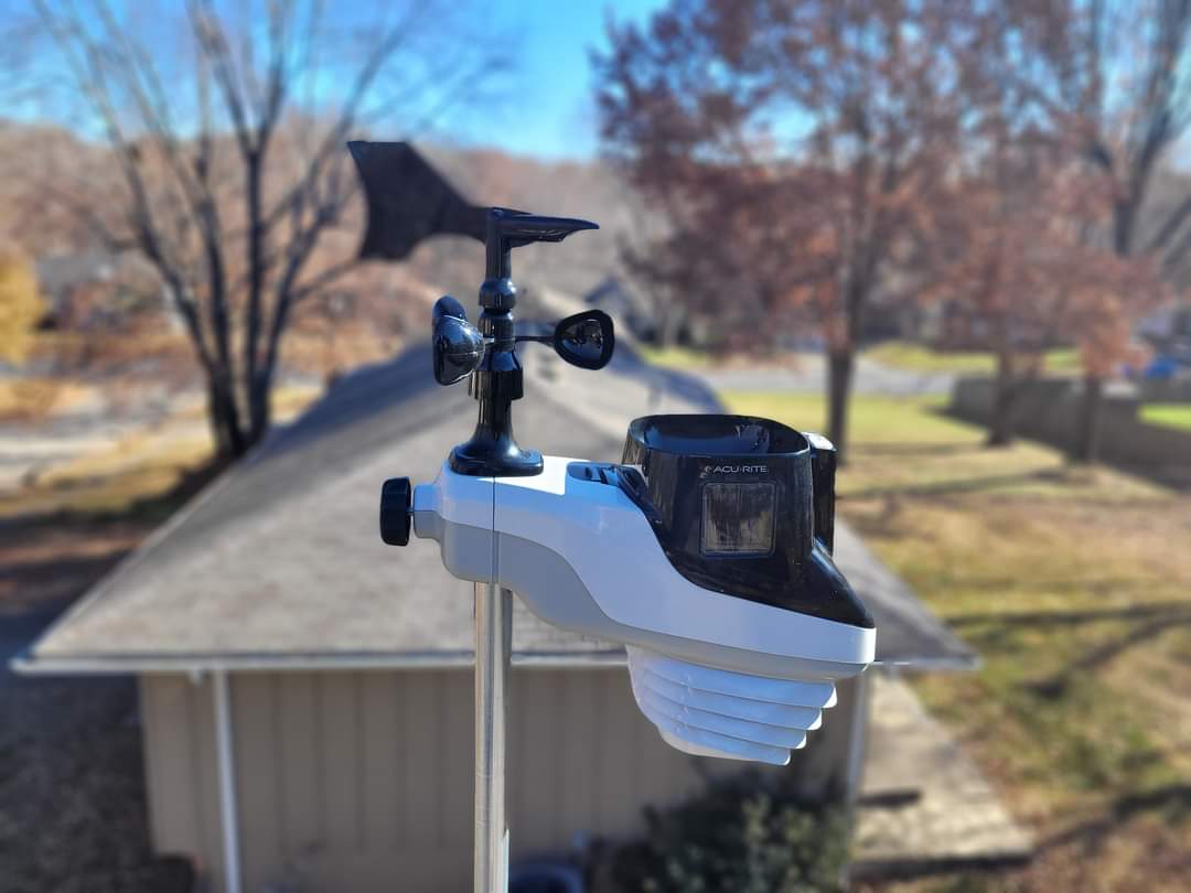
According to the AcuRite Atlas weather station, we are at a temperature of 25°. It is a big shift compared to the 60 we had yesterday. The dew point is at 19° and very dry. Winds are at 6 mph out of the west. The relative humidity is at 76%. The skies are partly cloudy.

Blue Springs Forecast

Today temperatures will continue to drop to a low of about 19° give or take, by 10 this morning. We are looking at a high of 29 degrees by 3 pm. Wind gusts will peak at about 31 mph or 27 knots by 6 am. Winds will be above 10 mph for the day. Sunshine will dominate most of the day with clear to mostly clear skies. No precipitation is expected for today.

Blue Springs Weather HRRR model.
HRRR Model at 3 pm
Blue Springs forecast Model of wind gusts at 6am
HRRR Wind Gust Model

Conclusion

All in all, today is going to be cold, but at least we have the sunshine. While I have your attention, please consider supporting my new weather research site called Project Stormfront. There you will find real scientific studies and actual results as I dive into our weather and what is involved, and what causes it. I will get into the granular details of how God takes care of the weather and what is revealed to us. Please consider subscribing so that you will receive direct communication from me as I go on this adventure. I will utilize lots of technology and resources l, including personally designed equipment to detect specific elements and events. So please jump over and check it out.

Blue Springs Weather Winter Thunderstorms?

Good morning Blue Springs and Jackson County! Blue Springs Weather will be enjoyable today. We have some spring activity going on today. It could bring us some severe weather. If any severe weather happens today, it will be between 5 and 9 am this morning and again between 6 pm and 5 pm. Those are the times when the Convective Available Potential Energy (CAPE) is the most. We already had a few drops of rain this morning, giving us a trace for this morning’s COOP report.

Current Blue Springs Weather Conditions

We are currently at 59.5° and 79% relative humidity. The barometric pressure is 29.4 inches and steady. Winds are at 4 mph from the WSW. The dew point is at 55°. Pretty close to the minimum required moisture.

Blue Springs Weather HRRR Forecast map.
HRRR Blue Springs Weather Forecast Map

For western Jackson County, we will start the main system at about 6 am, give or take. 7 am for the rest of the county. The system will be around till about 2 pm, and a second round will come into the area from about 3 pm to 4 pm. Both rounds have the possibility of Supercell capability. We are still early in the season for this sort of Blue Springs weather, so these may be weak, severe thunderstorms.

That is about it for today. Take care, everyone.

Blue Springs Weather Convective Forecast
Storm Prediction Center Blue Springs Weather Convective Weather Outlook

My extended forecast gives more for the rest of the week. I cannot wait till we head into spring. I am curious if this cooler weather will hang on even though we are sitting at a solar maximum. Only time will tell.

Please make sure you shoot over to my weather research page and see what kind of research I am diving into,

Blue Springs Forecast – Spring-like Weather

Blue Springs Forecast for rain.

Blue Springs Forecast for Monday, February 20, 2023. Good evening everyone. Here are our current conditions as of 6:16 PM tonight. The current temperature is sitting at 54.5°. We had a high of 62°. The barometric pressure is 29.8 inches and steady. Winds are at 2 mph from the southeast. The dew point is at 29°, and the relative humidity is at 34%. The skies are cloudy.

Blue Springs Forecast

We are heading into spring-like weather this week, with temperatures in the 50s and 60s during the day and in the 30s over the evening hours. The temperature will be back down to the 30s during the day. By Thursday evening, the temperature will struggle to get to 31°. By Friday morning at about 7:00, the temperatures will be in the upper teens.

We may see some snow on Friday, but all the accumulation will be way north in the Minnesota area, which looks like there is a pretty good possibility of some impressive snow amounts there. We may be dealing with rain this Wednesday morning and the possibility of snow on Friday. The rain could be significant enough to give us a decent ground drenching. The WPC tells us we could see up to a quarter of an inch or more in our area.

Blue Springs Forecast from WPC for Rain in excess of three quarters of an inch or higher

On another note, I hope you will consider supporting my weather research page called Project Stormfront. There I will be posting true scientific research without the agendas. I have already moved my research paper on solar intensity to that site and tweaked it a bit more.

High Pressure Dominance Today

Blue Springs Weather Conditions

Here is where we sit with the current Blue Springs weather. Barometric pressure will dominate the day. The current pressure is 30.52 and steady. The temperature as of 09:34 am is at 23.1° F. The relative humidity is at 64%. Winds are at eight mph from the NW. The Skies are clear. You can get what the NWS of Pleasant Hill has from here.

Barometric Pressure Pain Alert

The pressure will continue to be pretty high throughout the day today. Those who are pressure sensitive will be dealing with the results of the pressure.

The Forecast

The forecast for today’s Blue Springs Weather and over the next few days. Temperatures today will be about 33° F, give or take, by 3 pm. By 6 pm, we are down a couple of degrees to 31° F. Skies will be mostly clear today with plenty of sunshine. The temperature is pretty close to my long-range weather from February 6th.

Weather model of HRRR for Blue Springs and Jacksons County MO

HRRR Model shows a high temperature of 33° F.

Three-Day Forecast For Blue Springs

  • Friday night low of 27° F. Skies clear. No precipitation.
  • Saturday’s high of 46° F. Skies clear. No precipitation.
  • Saturday night’s low of 32° F. Skies clear. No precipitation.
  • Sunday’s high of 53° F. Skies clear. No precipitation.
  • Sunday night’s low of 32° F. Skies cloudy. No precipitation.

Conclusion

It looks like the weather this weekend for Blue Springs will be decent, especially for Sunday night’s Super Bowl. I will continue to monitor our conditions. Hopefully, those who have issues with pressure changes will be able to handle the high pressure of today. If anything changes, I will reach out on Facebook or Twitter. Take care of yourselves and be safe this Sunday. My prediction for the game this Sunday is still a win in overtime for the Kansas City Chiefs. Go Chiefs! MP

Blue Springs Weather Long Range Weather Forecast

Blue Springs Weather from GFS

As Blue Springs Weather begins to transition into spring. Maybe. Keep in mind that the Earth does not rotate perfectly; we will be flip-flopping when it comes to temperature and precipitation. The cold is not going away; temperatures will tease us over the next ten days, so don’t put away those winter coats.

Blue Springs Weather Forecast Breakdown

  • Tue 7 High of 48
  • Wed 8 High of 40 – Rain Rain possible
  • Thur 9 High of 47 Rain possible
  • Thur 9 High of 47 Rain possible
  • Fri 10 High of 34 Snow possible Early Morning 3 am
  • Sat 11 High of 41
  • Sun 12 High of 50 Windy

Conclusion

I still think winter will hang on, and temperatures will be cooler as we transition through the Grand Solar Minimum. As we progress through this natural transition, I think our summers will be cooler than usual. We may hit a few hot days, but I would be surprised if we have much of a summer. You can get more information on the GFS from the College of Dupage.

Ice Ice Baby – Possible Significant Impact

I put ice twice in the title because we may have a possibility of two rounds of ice over a week and a half time frame. It has been a while since we have dealt with any ice. We will talk about that shortly. Here is our current Blue Springs Weather. As of 7:50 pm, the temperature is at 30.2°. Pressure is sitting at 30.02 inches and steady. Winds are out of the NNW at 9 mph. The relative humidity is at 81%. The dew point is at 27°. The skies are hazy.

Cold and Breezy

Make sure you dress for the environment tomorrow. The winds will be about 15 mph tomorrow, right at kick-off.

HRRR Wind Gusts 5 pm.

Conclusion

Tomorrow evening we will be getting it. If you are coming up from the South from the Adrian area and 49 highway, you will be dealing with some tomorrow morning around 8 am. Jackson County will be dealing with ice tomorrow night with a start time of 7 pm and will move north, where the rest of the county will be covered by 8 pm. Tomorrow temperature will be around 22° give or take, by 4 pm.

In the second round, if it holds out, is on Wednesday February 8th and it may be more debilitating. The Ice accumulation amounts may be as high as 0.21 inches for Jackson County. That is enough ice to cause serious driving issues, fallen trees, and power outages. Keep in mind that this particular time is a week and a half out, and it will have plenty of time to change.

That is pretty much it for today. Take care, everyone, and be safe tomorrow. MP.

Breezy and High Winds Today

Good morning. Here is today’s Blue Springs weather. The current temperature is 34.3°. Relative humidity at 69%. Pressure is at 29.94 inches and steady—Dewpoint at 27°. Winds are at 10 mph out of the south. Skies are clear at this time but will shift to cloudy, and there will be short periods of clear skies.

Forecast

Here is the latest forecast for today. The temperature will peak to about 49° today at 1pm and should melt the rest of the residual snow that we have. There is currently about 0.4 inches of snow left on the ground.

HRRR Models show a high of 49° by 1 pm today.

The main issue we will be dealing with today will be the winds. It is likely we will end up with a high wind advisory today. Winds will peak to about 46 mph between 9am and 11am today.

HRRR Wind Gust Models – Peak between 9 am and 11 am with gusts as high as 46 mph.

Conclusion

Tomorrow’s temperature will be around the mid to upper 50s but by evening the temperatures will begin to tank around 6pm and 7pm. Looks like temperatures will be in the teens by 6am Sunday morning,

HRRR Temperature 6am Sunday.

As far as precipitation goes, nothing is to be expected over this weekend. That is about it for today’s Blue Springs weather and Jackson County, take care and enjoy your Friday.

Winter Storm Round Two Tuesday Evening

Ready for round two? Here is the latest forecast for tomorrow’s Blue Springs Weather and Jackson County and its impact. Here is the breakdown.

Forecast

6 am Tuesday, System arrives with rain and temperature at 38 degrees.
11 pm Tuesday Rain shifts to snow. Some snow may be heavy.
The system leaves the area by 7 am Wednesday.

Liquid precipitation amounts are not much and look to be about 0.26 inches of precipitation.

Snow amounts for the HRRR models are a little over 1 inch for Jackson County and the Blue Springs area. The Weather Prediction Center shows a 10 to 40% chance of snow accumulations of 4 inches and higher. Don’t hold your breath. There is a 50-60% chance of snow accumulations of 2 inches or greater; for 1 inch or greater, we are at an 80-90% chance. So with those numbers, we are guaranteed 1 inch of snow and maybe a little more. I am sure these models will change again by tomorrow, and if they do, I will reach out again.

Conclusion

The impact will be minor to moderate, depending on the part of Jackson County you live in. The Downtown area is moderate.

That is pretty much it for today.